
PHANTOM 4 RTK

Related products
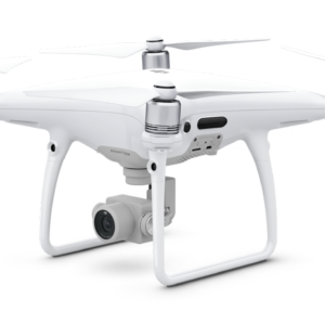
PHANTOM 4 RTK
The Phantom 4 RTK is a smart mapping and imaging drone capable of highly accurate mapping functions. The aircraft has a built-in DJI Onboard D-RTKTM, which provides precision data for centimeter-level positioning accuracy*. Multi-directional obstacle sensing achieved through vision and infrared sensors enables intelligent obstacle avoidance during flight and indoor hovering and flight. The Phantom 4 RTK records videos at 4K and captures 20 megapixel photos. The OCUSYNCTM HD video downlink built into both the aircraft and remote controller ensures a reliable and stable transmission.
Aircraft
| Takeoff Weight | 1391 g |
|---|---|
| Diagonal Distance | 350 mm |
| Max Service Ceiling Above Sea Level | 19685 ft (6000 m) |
| Max Ascent Speed | 6 m/s (automatic flight); 5 m/s (manual control) |
| Max Descent Speed | 3 m/s |
| Max Speed | 31 mph (50 kph)(P-mode) 36 mph (58 kph)(A-mode) |
| Max Flight Time | Approx. 30 minutes |
| Operating Temperature Range | 32° to 104° F (0° to 40℃) |
| Operating Frequency | 2.400 GHz to 2.483 GHz (Europe, Japan, Korea) 5.725 GHz to 5.850 GHz (United States, China) |
| Transmission Power (EIRP) | 2.4 GHz CE (Europe) / MIC (Japan) / KCC (Korea) :< 20 dBm5.8 GHz SRRC(China) / FCC(United States)/NCC(Taiwan,China):< 26 dBm |
| Hover Accuracy Range | RTK enabled and functioning properly: Vertical:±0.1 m;Horizontal:±0.1 mRTK disabled Vertical:±0.1 m(with vision positioning ); ±0.5 m(with GNSS positioning) Horizontal:±0.3 m(with vision positioning); ±1.5 m(with GNSS positioning) |
| Image Position Offset | The position of the camera center is relative to the phase center of the onboard D-RTK antenna under the aircraft body’s axis:(36, 0, and 192 mm) already applied to the image coordinates in Exif data. The positive x, y, and z axes of the aircraft body point to the forward, rightward, and downward of the aircraft, respectively. |
Mapping Functions
| Mapping Accuracy ** | Mapping accuracy meets the requirements of the ASPRS Accuracy Standards for Digital Orthophotos Class Ⅲ ** The actual accuracy depends on surrounding lighting and patterns, aircraft altitude, mapping software used, and other factors when shooting. |
|---|---|
| Ground Sample Distance(GSD) | (H/36.5) cm/pixel, H means the aircraft altitude relative to shooting scene (unit: m) |
| Data Acquisition Efficiency | Max operating area of approx. 1 km² for a single flight(at an altitude of 182 m, i.e., GSD is approx. 5 cm/pixel, meeting the requirements of the ASPRS Accuracy Standards for Digital Orthophotos Class Ⅲ |
Vision System
| Velocity Range | ≤31 mph(50 kph) at 6.6 ft(2 m) above ground with adequate lighting |
|---|---|
| Altitude Range | 0-33 ft(0 – 10 m) |
| Operating Range | 0-33 ft(0 – 10 m) |
| Obstacle Sensing Range | 2-98 ft(0.7-30 m) |
| FOV | Forward/Rear: 60° (horizontal), ±27° (vertical) Downward: 70° (front and rear), 50° (left and right) |
| Measuring Frequency | Forward/Rear:10 Hz; Downward: 20 Hz |
| Operating Environment | Surfaces with clear patterns and adequate lighting(> 15 lux) |
Camera
| Sensor | 1″ CMOS; Effective pixels: 20 M |
|---|---|
| Lens | FOV 84°;8.8 mm / 24 mm(35 mm format equivalent:24 mm); f/2.8 – f/11, auto focus at 1 m – ∞ |
| ISO Range | Video:100-3200(Auto) 100-6400(Manual);Photo:100-3200(Auto) 100-12800(Manual) |
| Mechanical Shutter Speed | 8 – 1/2000 s |
| Electronic Shutter Speed | 8 – 1/8000 s |
| Max Image Size | 4864×3648(4:3); 5472×3648(3:2) |
| Video Recording Modes | H.264,4K:3840×2160 30p |
| Photo Format | JPEG |
| Video Format | MOV |
| Supported File Systems | FAT32(≤ 32 GB); exFAT(> 32 GB) |
| Supported SD Cards | MicroSD, Max Capacity: 128 GB. Class 10 or UHS-1 rating required Write speed≥15 MB/s |
| Operating Temperature Range | 32° to 104° F (0° to 40℃) |
Intelligent Flight Battery(PH4-5870mAh-15.2V)
| Capacity | 5870 mAh |
|---|---|
| Voltage | 15.2 V |
| Battery Type | LiPo 4S |
| Energy | 89.2 Wh |
| Net Weight | 468 g |
| Charging Temperature Range | 14° to 104℉(-10° to 40℃) |
| Max charging Power | 160 W |
Intelligent Battery Charing Hub(WCH2)
| Input Voltage | 17.3 – 26.2 V |
|---|---|
| Output Voltage and Current | 8.7 V,6 A;5 V,2 A |
| Operating Temperature | 41° to 104℉(5° to 40℃) |
SDK Remote Controller
| Operating Frequency | 2.400 GHz to 2.483 GHz (Europe, Japan, Korea) 5.725 GHz to 5.850 GHz (Other countries/regions) |
|---|---|
| EIRP | 2.4 GHz CE / MIC / KCC: < 20 dBm5.8 GHz FCC / SRRC / NCC: < 26 dBm |
| Max Transmission Distance | FCC / NCC: 4.3 mi (7 km); CE / MIC / KCC / SRRC: 3.1 mi (5 km) (Unobstructed, free of interference) |
| Built-in Battery | 6000 mAh LiPo 2S |
| Operating Current / Voltage | 1.2 A @ 7.4 V |
| Mobile Device Holder | Tablets and smartphones |
| Operating Temperature | 32° to 104° F (0° to 40° C) |