
DJI AGRAS T16

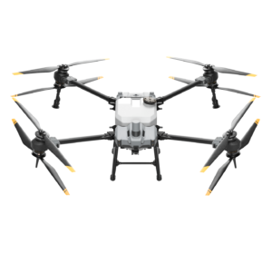

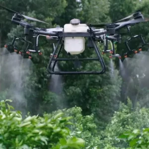
DJI AGRAS T16
The Agras T16 has an improved overall structure with modular design and supports the highest payload and widest spray width ever in a DJI agricultural drone. With powerful hardware, an AI engine, and 3D-operation planning, the T16 brings operation efficiency to a whole new level.
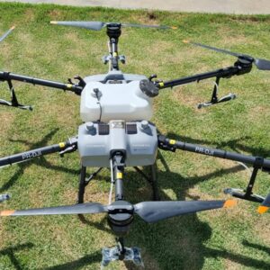
AIRFRAME
| Max Diagonal Wheelbase | 1883 mm |
|---|---|
| Dimensions | 2509×2213×732 mm (Arms and propellers unfolded) 1795×1510×732 mm (Arms unfolded and propellers folded) 1100×570×732 mm (Arms and propellers folded) |
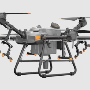
SPRAYING SYSTEM- SPRAY TANK
| Volume | Rated: 15 L, Full: 16 L |
|---|---|
| Operating Payload | Rated: 15 kg, Full: 16 kg |
SPRAYING SYSTEM – NOZZLE
| Model | XR11001VS (Standard), XR110015VS (Optional, purchase separately) |
|---|---|
| Quantity | 8 |
| Max Spray Rate | XR11001VS: 3.6 L/min, XR110015VS: 4.8 L/min |
| Spray Width | 4-6.5 m (8 nozzles, at a height of 1.5-3 m above crops) |
| Droplet Size | XR11001VS:130 – 250 μm XR110015VS:170 – 265 μm (Subject to operating environment and spray rate) |
SPRAYING SYSTEM – FLOW METER
| Measurement Range | 0.45-5 L/min |
|---|---|
| Error | < ±2% |
| Measurable Liquid | CConductivity > 50 mS/cm (Liquids such as water or pesticides that contains water) |
FLIGHT PARAMETERS
| Operating Frequency | 2.4000 GHz-2.4835 GHz 5.725 GHz-5.850 GHz * |
|---|---|
| EIRP | 2.4 GHz SRRC/ CE / MIC/ KCC: < 20 dBm FCC / NCC: < 26 dBm 5.8 GHz SRRC/ NCC/ FCC: < 26 dBm |
| Total Weight (Excluding battery) | 18.5 kg |
| Standard Takeoff Weight | 41 kg |
| Max Takeoff Weight | 42 kg (At sea level) |
| Max Thrust-Weight Ratio | 2.05 (Takeoff weight of 39.5 kg) |
| Hovering Accuracy (With strong GNSS signal) | D-RTK enabled: Horizontal: ±10 cm, Vertical: ±10 cm D-RTK disabled: Horizontal: ±0.6 m, Vertical: ±0.3 m (Radar module enabled: ±0.1 m) |
| RTK/ GNSS Operating Frequency | RTK: GPS L1/L2, GLONASS F1/F2, BeiDou B1/B2, Galileo E1/E5 GNSS: GPS L1, GLONASS F1, Galileo E1 |
| Battery | DJI-approved battery pack (AB2-17500mAh-51.8V) |
| Max Power Consumption | 5600 W |
| Hovering Power Consumption | 4600 W (Takeoff weight of 39.5 kg) |
| Hovering Time** | 18 min (Takeoff weight of 24.5 kg with a 17500 mAh battery) 10 min (Takeoff weight of 39.5 kg with a 17500 mAh battery) |
| Max Tilt Angle | 15° |
| Max Operating Speed | 7 m/s |
| Max Flying Speed | 10 m/s (With strong GNSS signal) |
| Max Wind Resistance | 8 m/s |
| Max Service Ceiling Above Sea Level | 2000 m |
| Recommended Operating Temperature | 0° to 40°C (32° to 104°F) |
| * To comply with local laws and regulations, this frequency is not available in some countries or regions. ** Hovering time acquired at sea level with wind speeds lower than 3 m/s. |
FPV CAMERA
| FOV | Horizontal: 98°, Vertical: 78° |
|---|---|
| Resolution | 1280×960 30 fps |
| FPV Spotlight | FOV: 110°, Max brightness: 12 lux at 5 m of direct light |
DBF IMAGING RADAR
| Model | RD2418R |
|---|---|
| Operating Frequency | SRRC (China)/ CE (Europe)/ FCC (United States): 24.00 GHz-24.25 GHz |
| Power Consumption | MIC (Japan) / KCC (Korea): 24.05 GHz-24.25 GHz |
| EIRP | 15 W |
| Altitude Detection & Terrain Follow* | MIC/ KCC/ CE/ FCC: 20 dBm |
| Obstacle Avoidance System* | Altitude detection range: 1-30 m |
| IP Rating | Stabilization working range: 1.5-15 m |
| *The effective radar range varies depending on the material, position, shape, and other properties of the obstacle. |